This page describes how to develop a new point data file reader using the RAMADDA
point data framework. This framework is based around a record file reading framework. To provide
support for a new point data format all that is required is to define a new Java File class that
can create the Record class that knows how to read a record from the file.
vert_gldas.csv # PBO H2O Data Portal - http://xenon.colorado.edu/portal
- created 09-Feb-2014
- cast 39.191022 249.322687 2245.0 / station Lat. Lon. Elev.(m)
- Product Release Version 1.1
- Loading Model
- The monthly GLDAS loads were computed by Tonie van Dam's group
- at the University of Luxembourg
- Month, Day, and DOY are provided to make it easier to plot the loads
- Year, Month, Day, Dayofyear, North Load(mm), East Load(mm), Vert Load(mm)
2000, 1, 15, 15, 0.4, 0.2, -2.5
2000, 2, 15, 46, 0.6, 0.2, -3.4
2000, 3, 15, 75, 0.7, 0.1, -4.7
2000, 4, 15, 106, 0.8, 0.3, -4.5
2000, 5, 15, 136, 0.7, 0.2, -3.3
2000, 6, 15, 167, 0.3, 0.2, -2.0
2000, 7, 15, 197, -0.0, 0.1, -0.8
2000, 8, 15, 228, -0.2, 0.0, 0.3
2000, 9, 15, 259, -0.2, -0.1, 0.4
2000, 10, 15, 289, -0.2, -0.0, -0.3
2000, 11, 15, 320, -0.2, 0.1, -2.3
2000, 12, 15, 350, 0.0, 0.2, -2.8
2001, 1, 15, 15, 0.2, 0.3, -3.4
2001, 2, 15, 46, 0.3, 0.3, -4.0
2001, 3, 15, 74, 0.3, 0.2, -4.4
2001, 4, 15, 105, 0.4, 0.2, -3.8
2001, 5, 15, 135, 0.3, 0.1, -2.4
2001, 6, 15, 166, 0.2, 0.1, -1.0
2001, 7, 15, 196, -0.1, -0.1, 0.2
2001, 8, 15, 227, -0.2, -0.2, 0.8
2001, 9, 15, 258, -0.3, -0.2, 1.1
2001, 10, 15, 288, -0.3, -0.1, 1.2
2001, 11, 15, 319, -0.1, -0.1, 0.8
2001, 12, 15, 349, 0.1, -0.1, -0.3
2002, 1, 15, 15, 0.2, -0.1, -0.6
2002, 2, 15, 46, 0.3, -0.0, -0.7
2002, 3, 15, 74, 0.4, -0.0, -0.6
2002, 4, 15, 105, 0.4, 0.0, -0.2
2002, 5, 15, 135, 0.3, -0.0, 0.5
2002, 6, 15, 166, 0.1, -0.1, 1.5
2002, 7, 15, 196, -0.2, -0.2, 2.3
2002, 8, 15, 227, -0.3, -0.2, 2.7
2002, 9, 15, 258, -0.3, -0.2, 2.0
2002, 10, 15, 288, -0.3, 0.1, 1.3
2002, 11, 15, 319, -0.2, 0.2, 0.7
2002, 12, 15, 349, -0.1, 0.2, 0.2
2003, 1, 15, 15, 0.1, 0.2, -0.3
2003, 2, 15, 46, 0.3, 0.1, -0.7
2003, 3, 15, 74, 0.3, 0.2, -1.2
2003, 4, 15, 105, 0.3, 0.1, -0.9
2003, 5, 15, 135, 0.3, 0.1, -0.4
2003, 6, 15, 166, 0.0, 0.1, 0.8
2003, 7, 15, 196, -0.3, 0.0, 1.8
2003, 8, 15, 227, -0.5, -0.1, 2.5
2003, 9, 15, 258, -0.5, -0.0, 2.4
2003, 10, 15, 288, -0.4, 0.0, 2.4
2003, 11, 15, 319, -0.3, 0.1, 1.9
2003, 12, 15, 349, -0.1, 0.1, 1.2
2004, 1, 15, 15, 0.1, 0.1, 0.5
2004, 2, 15, 46, 0.2, 0.1, 0.1
2004, 3, 15, 75, 0.2, 0.1, -0.4
2004, 4, 15, 106, 0.1, 0.2, -0.1
2004, 5, 15, 136, 0.1, 0.2, 0.6
2004, 6, 15, 167, -0.0, 0.2, 1.2
2004, 7, 15, 197, -0.3, 0.2, 1.8
2004, 8, 15, 228, -0.4, 0.1, 2.4
2004, 9, 15, 259, -0.4, 0.1, 2.2
2004, 10, 15, 289, -0.3, 0.1, 1.3
2004, 11, 15, 320, -0.2, 0.2, -0.5
2004, 12, 15, 350, -0.0, 0.3, -1.4
2005, 1, 15, 15, 0.0, 0.2, -2.9
2005, 2, 15, 46, 0.0, 0.2, -3.8
2005, 3, 15, 74, 0.1, 0.1, -3.7
2005, 4, 15, 105, 0.2, 0.0, -3.3
2005, 5, 15, 135, 0.3, -0.1, -2.7
2005, 6, 15, 166, 0.2, -0.1, -1.8
2005, 7, 15, 196, -0.1, -0.2, -0.1
2005, 8, 15, 227, -0.4, -0.3, 0.6
2005, 9, 15, 258, -0.4, -0.3, 0.9
2005, 10, 15, 288, -0.3, -0.2, 0.4
2005, 11, 15, 319, -0.2, -0.2, 0.0
2005, 12, 15, 349, 0.0, -0.1, -0.3
2006, 1, 15, 15, 0.3, -0.3, -1.1
2006, 2, 15, 46, 0.4, -0.2, -1.4
2006, 3, 15, 74, 0.5, -0.2, -1.7
2006, 4, 15, 105, 0.6, -0.3, -1.9
2006, 5, 15, 135, 0.4, -0.3, -0.8
2006, 6, 15, 166, 0.1, -0.4, 0.5
2006, 7, 15, 196, -0.3, -0.4, 1.6
2006, 8, 15, 227, -0.5, -0.4, 2.0
2006, 9, 15, 258, -0.6, -0.3, 1.9
2006, 10, 15, 288, -0.5, -0.1, 1.1
2006, 11, 15, 319, -0.3, -0.1, 0.7
2006, 12, 15, 349, -0.1, -0.0, 0.2
2007, 1, 15, 15, -0.0, 0.1, -0.7
2007, 2, 15, 46, 0.0, 0.0, -1.0
2007, 3, 15, 74, 0.2, -0.0, -0.9
2007, 4, 15, 105, 0.2, 0.1, -0.8
2007, 5, 15, 135, 0.1, 0.1, -0.0
2007, 6, 15, 166, -0.1, 0.0, 1.1
2007, 7, 15, 196, -0.4, -0.1, 2.2
2007, 8, 15, 227, -0.6, -0.2, 2.6
2007, 9, 15, 258, -0.6, -0.2, 2.7
2007, 10, 15, 288, -0.4, -0.2, 2.2
2007, 11, 15, 319, -0.2, -0.1, 2.0
2007, 12, 15, 349, -0.0, -0.0, 0.7
2008, 1, 15, 15, 0.1, -0.0, -0.4
2008, 2, 15, 46, 0.3, -0.0, -1.1
2008, 3, 15, 75, 0.4, 0.0, -1.3
2008, 4, 15, 106, 0.4, 0.1, -0.6
2008, 5, 15, 136, 0.2, 0.0, 0.3
2008, 6, 15, 167, 0.1, -0.0, 1.0
2008, 7, 15, 197, -0.3, -0.1, 2.2
2008, 8, 15, 228, -0.5, -0.1, 2.7
2008, 9, 15, 259, -0.5, -0.0, 2.4
2008, 10, 15, 289, -0.4, -0.0, 2.1
2008, 11, 15, 320, -0.1, -0.0, 1.6
2008, 12, 15, 350, -0.0, 0.0, 1.0
2009, 1, 15, 15, 0.2, 0.0, -0.1
2009, 2, 15, 46, 0.3, 0.0, -0.7
2009, 3, 15, 74, 0.5, -0.0, -0.7
2009, 4, 15, 105, 0.5, 0.1, -0.5
2009, 5, 15, 135, 0.4, 0.1, 0.1
2009, 6, 15, 166, 0.2, 0.0, 0.8
2009, 7, 15, 196, -0.1, -0.1, 1.7
2009, 8, 15, 227, -0.3, -0.1, 2.5
2009, 9, 15, 258, -0.4, -0.1, 2.7
2009, 10, 15, 288, -0.3, 0.0, 2.1
2009, 11, 15, 319, -0.1, 0.1, 1.6
2009, 12, 15, 349, 0.0, 0.2, 1.0
2010, 1, 15, 15, 0.2, 0.1, -0.1
2010, 2, 15, 46, 0.1, 0.1, -1.4
2010, 3, 15, 74, 0.2, 0.0, -1.6
2010, 4, 15, 105, 0.3, -0.0, -1.1
2010, 5, 15, 135, 0.3, -0.0, -0.5
2010, 6, 15, 166, 0.2, -0.1, 0.3
2010, 7, 15, 196, -0.2, -0.1, 1.4
2010, 8, 15, 227, -0.4, -0.2, 2.2
2010, 9, 15, 258, -0.3, -0.2, 2.4
2010, 10, 15, 288, -0.3, -0.2, 2.1
2010, 11, 15, 319, -0.1, -0.3, 1.5
2010, 12, 15, 349, 0.2, -0.4, 0.2
2011, 1, 15, 15, 0.4, -0.4, -1.4
2011, 2, 15, 46, 0.6, -0.4, -1.7
2011, 3, 15, 74, 0.7, -0.4, -2.3
2011, 4, 15, 105, 0.8, -0.5, -2.2
2011, 5, 15, 135, 0.8, -0.4, -1.9
2011, 6, 15, 166, 0.7, -0.4, -1.2
2011, 7, 15, 196, 0.2, -0.4, 0.3
2011, 8, 15, 227, -0.1, -0.5, 1.4
2011, 9, 15, 258, -0.2, -0.5, 1.9
2011, 10, 15, 288, -0.2, -0.4, 1.6
2011, 11, 15, 319, -0.0, -0.3, 1.3
2011, 12, 15, 349, 0.0, -0.2, 0.9
2012, 1, 15, 15, 0.2, -0.2, 0.5
2012, 2, 15, 46, 0.3, -0.2, -0.0
2012, 3, 15, 75, 0.3, -0.3, -0.1
2012, 4, 15, 106, 0.3, -0.3, 0.2
2012, 5, 15, 136, 0.2, -0.3, 1.1
2012, 6, 15, 167, 0.0, -0.4, 2.2
2012, 7, 15, 197, -0.3, -0.6, 3.1
2012, 8, 15, 228, -0.5, -0.6, 3.5
2012, 9, 15, 259, -0.5, -0.6, 3.6
2012, 10, 15, 289, -0.5, -0.5, 3.4
2012, 11, 15, 320, -0.2, -0.4, 3.0
2012, 12, 15, 350, -0.0, -0.5, 2.3
2013, 1, 15, 15, 0.0, -0.3, 1.6
2013, 2, 15, 46, 0.1, -0.3, 1.3
2013, 3, 15, 74, 0.2, -0.2, 1.2
2013, 4, 15, 105, 0.2, -0.1, 1.3
This can be ingested without just the following properties file.
The data file has latitude, longitude and elevation in the header. To use these
we define a "pattern" attribute for these fields.
We're going to look at meteorological data from
the Antarctic Meteorology Research Center (AMRC).
Some example data can be found
on the
.
To run this from the command line (assuming you've installed the pointtools):
We need to write some code because the point data API expects geo and time referencing so the
AmrcFinalQCPointFile code extracts the metadata from the header and
tacks on site,lat,lon,elevation to each row (well, sortof).
The API sees:
In the AmrcFinalQCPointFile.prepareToVisit method the 2 line header is read, the
georeferencing metadata is then used to define the fields as, using value="..." field
attribute to insert the metadata values.
This allows us to take the metadata in the header (e.g., location) and have it applied to the data records.
The base point code (for now) doesn't handle the particular way of expressing time so the
AmrcFinalQCPointFile code handles it in its processAfterReading method.
This parses the date/time from the column values and sets the time on the Record.
Mcords is one of the airborne LiDAR data sets from NASA's Operation IceBridge. Example IceBridge data can be found
on the
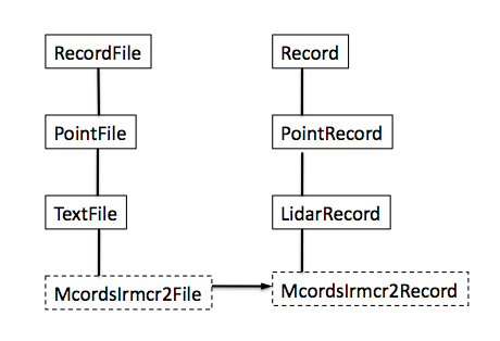
To provide support for this data format we need to create 2 classes-
McordsIrmcr2File and McordsIrmcr2Record. The basic structure is that the "File" classes
are what get insantiated and can do some initialization (e.g., read the header) and
create a Record class that is used to read and store the values for one line or record of data.
One could hand write both the File and the Reader class but RAMADDA provides a data dictionary based
code generation facility.
In the Icebridge package there is a
script that contains the data dictionary
that generates Java code for the various readers. To run this do:
class.
This class contains a
generated McordsIrmcr2Record class that does the actual reading. This code is generated by the
generateRecordClass procedure
defined in ../..record/generate.tcl. The following arguments are used
The generated McordIrmcr2File class has a main that can be used to test, e.g.:
To use the file reader within RAMADDA one has to add a new RAMADDA entry type in a plugin.
The main RAMADDA point plugin is located here:
In icebridgetypes.xml is the entry definition for the Mcords file type.
This specifies a record.file.class property that is used to instantiate the file reader.
The ATM QFit data is a binary format. There are 3 different record structures - 10 word, 12 word and 14 word.
We use the code generation facility to generate readers for each of these formats.
The records all have some common fields - relativeTime, latitude, longitude and elevation.
These fields have various scaling factors.
We declare those fields in the base (hand written) QfitRecord class and that class in turn implements the
getLatitude, getLongitude, etc., methods, scaling the integer values accordingly.
The QfitFile is not generated. It handles the logic of determining what record format the file is in, its endianness and pulls out
the base date from the file name.