| | For Repository Administrators |
|
Point Data Documentation
|
|
3.0 Managing point data in RAMADDA
There are two main types of Point related entries you can create.
The first is the Point Data type. Entries of this type refer to a
single Point data file.
You can upload a file directly to RAMADDA:
-
Navigate to the Folder you want to upload the file to
-
From the File menu select "New Entry".
- Select an appropriate Point Data type:
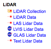
There is no specific functionality associated with the
LAS, LVIS and GLAS entry types. If you have this type of data
you could just select "LiDAR Data". But, specifying the type
would allow you to search for files of particular types.
See below for more information regarding
supported file formats.
-
Now that you have selected the type you can upload the file
through the next form.
See the Harvester section
to find out how to automate this process.
A Point Data type in RAMADDA provides a number of services (viewing, data access, etc)
The Point Collection type is used for aggregating a set of Point Data entries
and providing the POINT data access services (conversion, subset, etc) to the whole
collection.
Furthermore, the Point Data entries are not accessed directly
from queries through the POINT API from external portals (e.g., Open Topography).
The Point Collection entries are what is accessed by external portals and through
the top-level POINT search UI.
So, if you want to make data collections available to OpenTopography
then create a Point Collection folder and add the Point Data to it.
| | For Repository Administrators |